



Lewes Tube Map Art Print - A Gift For Locals
- Precio regular
-
£42.00 - Precio regular
-
- Precio de venta
-
£42.00
No se pudo cargar la disponibilidad de recogida
Add a second Tube Map print - Save 20% applied automatically at checkout, no code needed.
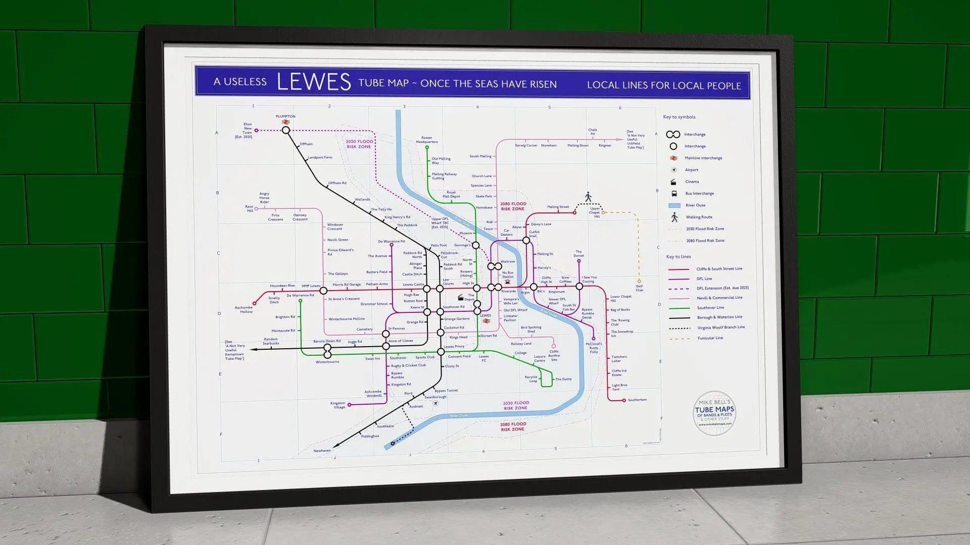
A gift for Lewes people who have never found a single thing worth hanging that is actually about Lewes, because this draws the town once the seas have risen, with the 2030 and 2080 flood risk zones laid straight over the network. It is titled A Useless Lewes Tube Map. It is not trying to help you get anywhere.
Giclée on 230gsm premium fine art paper, textured matte, archival and acid-free. Produced unframed or framed. Deeply researched and designed by me in East Sussex.
I drew this one during the 2020 lockdown, from the location map and from living here, turning the town into a transit network with landmarks, streets and local quirks as stations. Eight lines, the River Ouse, and a subtitle that reads Local Lines For Local People.
Why this Lewes tube map art makes a gift Lewesians keep
The usual town souvenir could be any town. This one only works if you know Lewes, and the flood zones are the reason it has an edge to it rather than just being a joke.
Every line has something buried in it. It rewards every closer look.
What is on the map
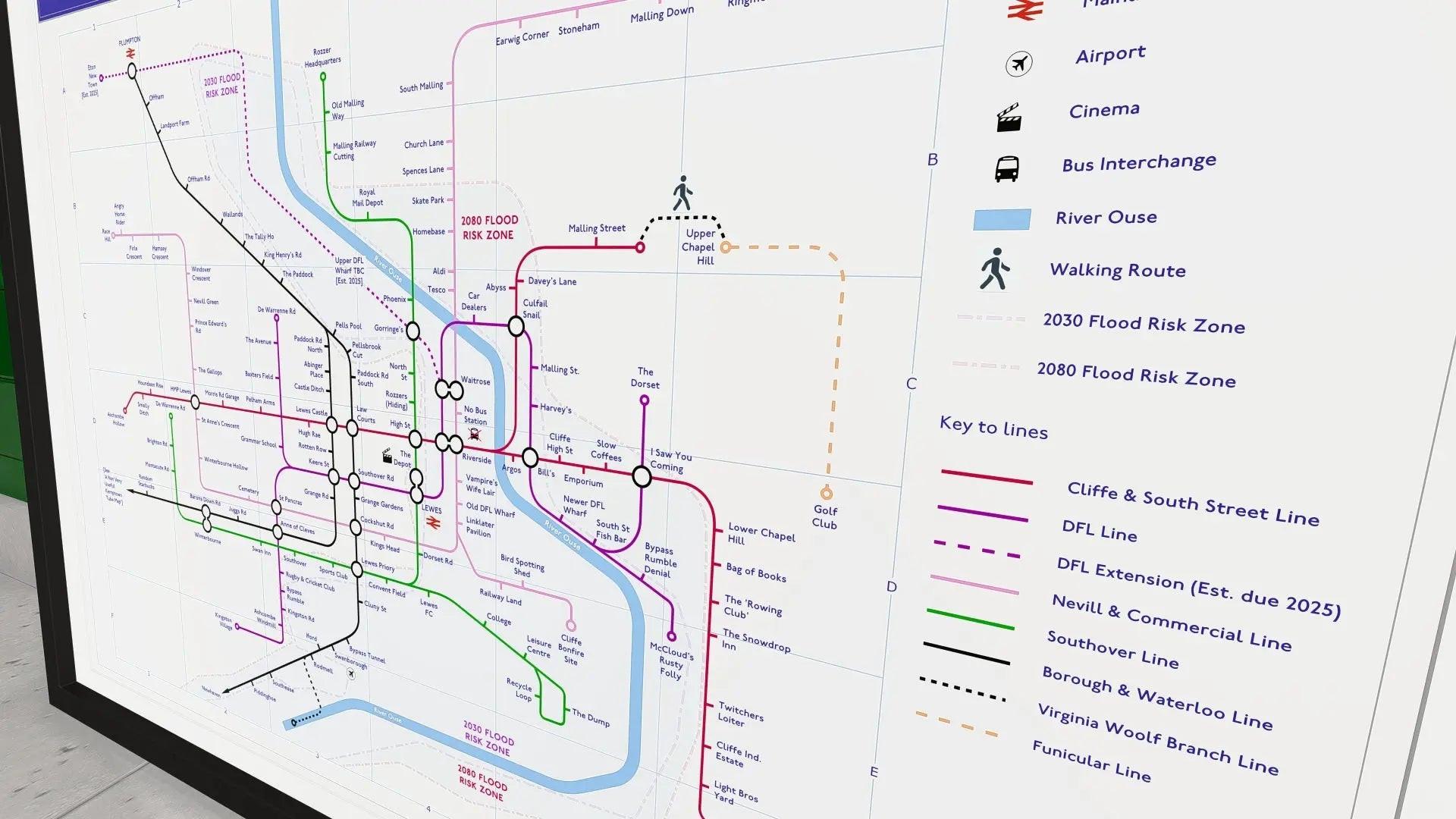
The lines are the Cliffe and South Street, the Nevill and Commercial, the Southover, the Borough and Waterloo, the Virginia Woolf Branch Line down to Rodmell, and a Funicular Line up to the golf club.
Then there is the DFL Line, which anyone who has lived here for more than a fortnight will understand on sight. It calls at Old DFL Wharf and Newer DFL Wharf, there is an Upper DFL Wharf marked TBC, and a DFL Extension due in 2025.
Nearby you will find Eton New Town, also marked as established 2025, which is the same observation made from a slightly different angle.
The station names are where the map does its real work. Rozzer Headquarters and, separately, Rozzers (Hiding). Bypass Rumble, and further along, Bypass Rumble Denial. Random Starbucks, Angry Horse Rider, Twitchers Loiter, I Saw You Coming, Slow Coffees, Culfail Snail, Abyss and Smelly Ditch.
There is a No Bus Station, drawn with a bus interchange symbol. Swanborough has an airport symbol. The Rowing Club is in quotation marks, and I stand by that.
The real Lewes is all present too. Harvey's, Lewes Castle, Anne of Cleves, Lewes Priory, Pells Pool, HMP Lewes, the Cliffe Bonfire Site, Lewes FC, the Linklater Pavilion, Keere Street, Rotten Row, and The Depot with its own cinema symbol.
Two more sit there for locals to spot. Vampire's Wife Lair, and McCloud's Rusty Folly.
How I make each print
Each one is a Giclée on 230gsm premium fine art paper with a textured matte finish, archival and acid-free, so the colours hold for years. Choose A2 or A1, unframed or framed, ready to hang in a hallway, kitchen or local business.
| Size | UK | USA / CAN / AUS equivalent | Orientation |
|---|---|---|---|
| A2 | 594 x 420 mm (23 x 16 in) | 24 x 18 in | Landscape |
| A1 | 841 x 594 mm (33 x 23 in) | 36 x 24 in | Landscape |
FAQ
Why are there flood zones on it?
Because the map is set once the seas have risen. The 2030 and 2080 flood risk zones are drawn over the network, which in a town that has flooded before is only partly a joke.
Is it an accurate map?
No, and the title says so. It is a tube map, so it is about connections rather than distances.
What is the DFL Line?
If you need to ask, you are probably on it.
Are the stations real places?
Many are. Harvey's, the Castle, Pells Pool, the Priory, HMP Lewes and The Depot are all on there, alongside the invented ones.
Is there an Uckfield version?
There is, and this map points across to it. It is called A Not Very Useful Uckfield Tube Map.
What are the framing options?
Unframed, or supplied framed and ready to hang.
Related Tube Maps
The Uckfield Tube Map Art Print is the companion piece, and this map points across to it. Both sit in the Lewes and Uckfield collection at mikebellmaps.com.
For more Sussex drawn the same way, the Brighton and Hove Albion Map Art Print covers the club rather than the town.
What people say about my tube map designs
“Brilliant idea... really like what you’ve done, Mike.”
Billy Bragg, on the Billy Bragg discography map
“It is truly amazing.”
Bruce Springsteen Archives, Monmouth University, on the Bruce Springsteen discography map
“Awesome!”
Warren Ellis, on the The Shining plot map



Let customers speak for us

Great gift for a Bowie fan ! Very nicely done and item was well packaged and arrived in Canada quickly. Totally satisfied.
Having seen your work in the Guardian a few weeks previously and looked at your website, it didn't take much to press the 'Add to bag' button and easily make my purchase. It arrived in good time and well wrapped. Thank you!

This was a gift for someone who is so hard to buy for and he loves it. It's almost as though it was made for him alone! It's so clever! Thank you
Couldn't have been easier. Got it really quickly as far as I'm concerned, and given the cost of custom framing, the money for having this delivered framed was well spent. The print arrived in excellent condition, frame and all.

Incredible detail. I'm still studying it! Worth every penny.

This was a gift for my dad. He loved it! Amazing quality and the time it must have taken to research is evident. Thank you
Love this type of stuff
Fast and great shipping

Very well received from my brother in law as a birthday gift.
Arrived well in time and Mike replied to my email quickly and was very helpful.
fast delivery and tracking available all the way
Great piece of work, a lot of research and precision.
Beautiful, clean design and quality printing
Maybe having the role of the contributing artist would helpful

Bloody spot on cobba, I put my best Hawkwind mate on to you, I couldn't afford framed but I do it my end Thanks mate 👍, just a question for you, have many from Australia brought Hawkwind 👍
Good service. Kept me well informed.
Perfect - just as pictured

Excellent product and clear, quick delivery process. Couldn’t ask for more.


